Blogia

COMPAÑIA MINERA GUADALUPE 2005

PRELIMINARY INFORMATIVE PROFILEOF THE MINER CONCESSIONS “GUADALUPE 2005” AND “GUADALUPE 2006”

PRELIMINARY INFORMATIVE PROFILEOF THE MINER CONCESSIONS “GUADALUPE 2005 AND “GUADALUPE 2006

OWNER: SMRL. - “GUADALUPE 2005”

1.      INTRODUCTION: The present informative profile establishes a summarized way the geological-mineral-metallurgical of the referred property.

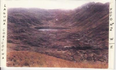
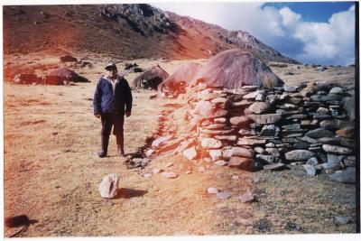
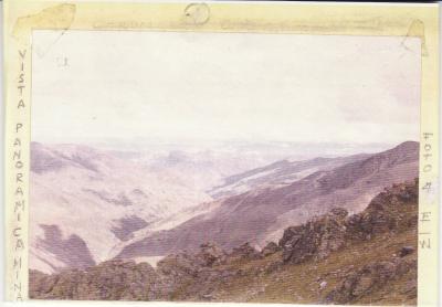
2.      LOCATION: Gongor´s village, Marias´s district, Dos de Mayo province, Huanuco department. Altitude of 4000 m. (meters above sea level).

3.      ROADS INTO THE CITYa.      ROUTE ONE: Lima-Huánuco 420 km._ Huánuco – Marías 126 Km._ Marías- -Mina 15 Km. Total: 561 Km. b.     ROUTE TWO: Lima – Pativilca 210 km._ Pativilca – Conococha 162 km._ Conococha – Tingo Chico 132 km. _ Tingo Chico – Mina 15 km. Total: 519 km.c.      ROUTE THREE: From Huánuco, currently it’s possible to take the route Huanuco – Punto Union 50 km., Punto Union – Tantacoto 30 km., from Tantacoto to the camping (Herradura Road) 6 km. It’s the shortest way to get over the concessions currently; and in the same time this part haven’t still been built, over flat land.d.     ROUTE FOUR: From Lima to Huanuco, by plane in one hour and then, use the route marked like fourth option.

4.      LEGAL ASPECT: The two miner concessions are still valid, properly registered in the respective registers.

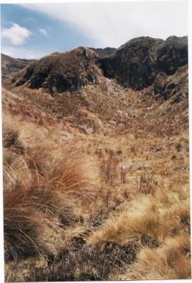
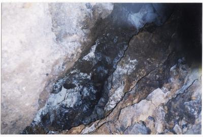
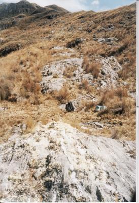
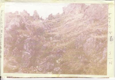
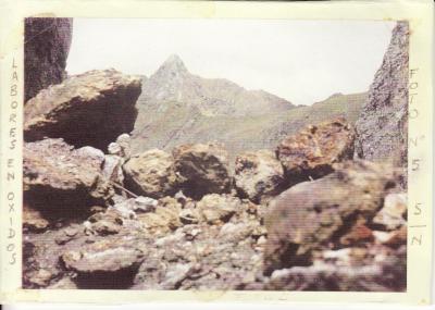
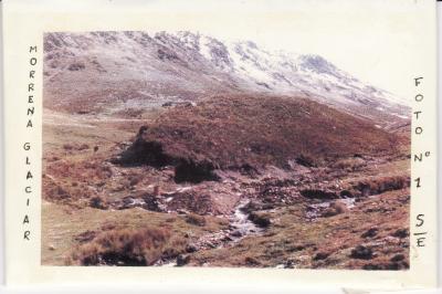
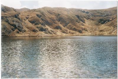
5.      REGIONAL AND LOCAL GEOLOGY: This wide zone belongs to the Eastern Andes Mountain Range, which is faced from south to north, from Bolivia to Ecuador. Structurally consist on a great complex of sedimentary rocks, metamorphoses, with intense folding, like interbedded filones (filones – layers). Black and gray slates predominate, intercrossed by numerous piroso quartz veinlets, with appreciable values of gold silver and other metals. The geological of this complex is considered between Pre-Cambrian and Paleozoic. The fossil testimonies are very few, but we can mention some presences of granolit hs and branqueopodos of the Silurian age. The direction of these meta-exquisite, is from of the northwest to southeast. Parallel to the Eastern mountain range that forms the high edge of the folding. The Folding, the metamorphosis, etc; obey to the more recent rocks of depth (granite, granodeorita); also, the relation of filioniano gold with different igneous rocks, especially with the granite, its hydrothermal origin, the profuse mineralization of gold, primary and secondary enrichment put under since always to the nature laws. To the tectonic action that produced the rise of the mountain range, it followed an intense glacial activity giving rise to the lateral and terminal moraine formation. Obviously, to the intense permanent erosion and the works of transport of the brooks and descending rivers, the formation of the laundries or pleasures obeys.

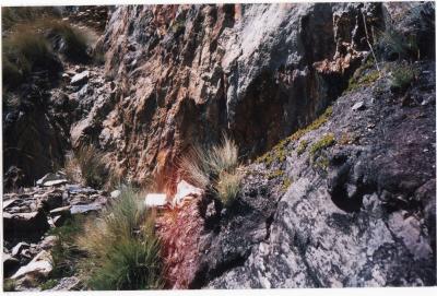
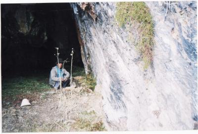
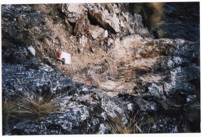
6.      EXPLORATION WORKINGS.- In one of the filones (main), it has been explored approximately 500 meters in length (of a total of 3000 meters), and a considered depth of one hundred meters with three meters of power average, whose probable results are:

Oxides        : 200 000 TM.Sulfides      :  300 000 TM.

The laws of the average head are the following: 

Gold           : 1.5 Gr. per TM. 

Copper      : 3.00 % per TM.

Silver         : 3  ounce per TM.

Zinc           : 3.00 % per TM.

Lead          : 2.00 % per TM.

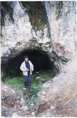
It deserves to clarify that the geologic studies have obeyed to prospections and explorations by gold; the recent quotations in the world-wide market of the prices of minerals allow us to include the mentioned studies, so that, it is needed to pay greater attention to conclude the works of exploration in the entire zone. Our proximity to the mining company SANTA LUISA and mining company ANTAMINA (in the heat of production), it allows us to relate us somehow with them. Greater information detailed on our mining concessions will be provided personally to whom will take interest in our optionable project. We only took as example a section of one of the filones and we still didn’t consider minerals scattered of gold and silver that they are characteristic of the Andean Eastern mountain range. The attached photografies give better references, replacing explanations, sometimes unnecessaries. Fundamentally, to continue the working explorations, it´s still necessary a carriage road of 12 to 15 km. from Tantacoto, or from Maynas by the west side of the same length approximately over rock. We consider very necessary diamond soundings, some tunnels, taking advantage of the bell form of the hill that easilly gets about 500 to 600 meters of altitude in the appreciable filones. In the same way, the folding (antisloping) in plastic rocks, shows antique works from Pre Inca´s ages and subsequent, that allows low exploration costs and a properly profitability. With these premises, we estimate attemptly an initial  investment of ONE MILLION DOLLARS, to place stores that justify fully favorable utilities to our company during three lusters has undertook directions and explorations, including investigations of ¨metallurgical miner secrets¨ of the antique peruvians, which principles are support over the Nature Laws, avoiding fudamentally THE ENVIRONMENTAL CONTAMINATION. Finally, we remark that for ovious reasons and in keeping with the politic traced for our company, the present report contribute a fundamental profile, with the commitment to be abundant when it´d be necessary.

ADDITIONAL 

Beginning from the “Analogy”, origin of all hypothesis, which evolution perfects the ideas, we provided you some essential information for your geologic - Mining – Metallurgical interpretation.  The Andean Eastern mountain for its origin and older formation has undergone later intrusions of igneous, carrying rocks of polymetallic, and mainly of precious minerals (Au, Ag).  In the Andean Eastern Peruvian mountain, north east , exists a silurian river basin of many kilometres square which area is being studied to the date partially. The structural appreciations agree analogically with the “Australia Bendigo Mining”, The Guayanas and Guyanas from Central America, Surinam and others up to the present production.In the present case, in a kilometre square  has been located scattered mineralof silver and gold, which results are the following:Au =  50 millions cubical square, with 1.5 grams by TM. (metric ton) equivalent to 4 million ounces by TM. Ag =  125 millions of  TM. (metric ton) with 4 ounces by TM, equivalent  to 500 millions ounces.Mineral densidad = 2.5 Security Factor (ratio)= 50%Total extension of the property = 7.5 Km2.Cost average of production $ 50.00 by Tm. Polymetallics.Cost average of production for scattered Au = $ 150.00 for ounce. With the exclusive purpose for immediate treatments with the interested investors in two types of deposits (scattered and seams), we are doing our best to give you the latest information nearly to reality.Also is important to let you know that there is a plain of two kilometres of length by ½ km of width that prepared will be useful for an exceptional airport.For further information e-mail us. Our location: A segment of mentioned Peruvian Cordillera (N-E), is a Siluriana River basin of several square kilometers whose area is studied partially: The structural appreciations analogically, agree with the mines I bless of Australia, the Guayanas and Guyana de Centro America, Surinam, etc, in present operation and production.  A small segment with the following results has been cubed:  

Au=50x106 m3 with 1,5 grs / METRIC TON.

Ag=200x106 m3 with 4 ounces/METRIC TON.  

Further information when one advances the possible agreement    

The policy of our company is to deal directly with the investor.


P, SMRL Guadalupe 2005

J. Soto I:

Contact phones in Lima – Peru:

00-51-1-426 8440

00-51-1-307 4162

00-51-1-376 3585

Get in touch to Hernan Cruz Rivera.

Mobile: 00-51-1-9047 1788

E-mail:

            coespro@hotmail.com         

            ciaminguadalupe@yahoo.es

PERFIL INFORMATIVO PRELIMINAR DE LAS CONCESIONES MINERAS “GUADALUPE 2005”Y “GUADALUPE 2006”

PERFIL INFORMATIVO PRELIMINAR DE LAS CONCESIONES MINERAS “GUADALUPE 2005”Y “GUADALUPE 2006” 

PROPIETARIA: SMRL.- “GUADALUPE 2005

1.           INTRODUCCION

El presente perfil informativo establece de manera muy resumida las características geológica- minera- metalúrgica de la propiedad referida. 

2.              UBICACIÓN:

Localidad pueblo de Gorgor, distrito de Marías, provincia Dos de Mayo, departamento de Huánuco, altura de 4,000 m.s.n.m. 

3.             ACCESOS:

  1. Ruta uno, Lima-Huánuco-420 Km.- Huanuco Marías 126 Km.- Marías – Mina 15 Km. Total 56 Km.
  2. Ruta dos, Lima – Pativilca 210Km. –Pativilca – Conococha 162 Km.-Conococha – Tingo Chico 132 Km.- Tingo Chico – Mina 15 Km.- total: 535 Km.
  3. Ruta tres, desde Huanuco, actualmente se puede tomar la ruta Huanuco – Punto Unión 50 Km.- Punto Unión – Tantacoto 30 Km.- De Tantacoto al campamento (camino herradura) 6 Km.- Es la más corta para llegar en la actualidad a las concesiones; y a la vez tramo que falta construir (una trocha carrosable), sobre terreno llano.
  4. Ruta cuatro.- De Lima a Huánuco, en avión en una hora y luego, usar la ruta señalada como cuarta opción.

4.     ASPECTO LEGAL

Las dos concesiones mineras se encuentran vigentes, debidamente inscritas en los Registros respectivos. 

5.     GEOLOGIA REGIONAL Y LOCAL

Esta vasta zona pertenece a la Cordillera Oriental de los Andes, cuya orientación es de Sur a Norte, desde Bolivia hasta el Ecuador.Estructuralmente constituye un gran complejo de rocas sedimentarias, metamorfizadas, con intensos plegamientos, como filones interestratificados (Filones - Capa). Predominan pizarras negras y grises entrecruzadas por numerosas venillas de cuarzo piritoso, con valores apreciables de oro, plata y otros metales.La edad geológica de este complejo se considera entre Pre – Cambriano y Paleozoico. Son muy pocos los testimonios fósiles, pero podemos mencionar algunas presencias de Graptolitos y Branqueópodos de la edad Silúrica.La dirección de estos meta – esquistos, es de Nor Oeste – Sur Este. Paralela a la Cordillera Oriental que forma la arista más elevada del plegamiento.Los Plegamientos, la metamorfización, etc. Obedecen a las intrusiones de rocas de profundidad mas recientes (granito, granodeorita); así mismo la relación del oro filioniano con la diferentes rocas igneas, en especial con el granito, su origen hidrotermal, la mineralización profusa del oro, enriquecimientos primario y secundario sometidas desde siempre a las leyes de la naturaleza. A la acción tectónica que produjo el levantamiento de la cordillera, siguió una intensa actividad glacial, dando lugar a la formación de morrenas laterales y terminales. Obviamente a la intensa erosión permanente y a los trabajos de acarreo de los riachuelos y ríos descendientes, obedece la formación e los lavaderos o placeres. 

6.     LABORES DE EXPLORACION

En un o de los filones (principal) se ha explorado aproximadamente 500 metros de longitud (de un total 3,000 metros), y una profundidad estimada de cien metros con tres metros de potencia promedio cuyos resultados probables son

Óxidos 200,000 TM. 

Sulfuros 300,000 TM.

Las Leyes de cabeza promedio son las siguientes:

Oro   :                1.5 Gr. Por TM.

Cobre:                 3.00 % por TM.

Plata:                  3 onz. Por TM.

Zinc:                   3.00 % por TM.

Plomo:                2.00 % por TM.

Merece aclarar que los estudios geológicos han obedecido a prospecciones y exploraciones por oro; las recientes cotizaciones en el mercado mundial de los precios de los más minerales nos permite incluir los estudios mencionados, de manera que, se necesita prestar mayor atención a concluir los trabajos de exploración en toda la zona.

Nuestra proximidad a las Compañía Minera SANTA LUISA y Compañía Minera ANTAMINA (en plena producción), nos permite relacionarnos de alguna manera con ellas.Mayores informes detallados sobre nuestras concesiones mineras se proporcionaran personalmente a los que tomen interés en nuestro proyecto opcionable.Solamente tomamos como ejemplo un tramo de uno de los filones y aun no consideramos los minerales diseminaos de oro y plata, que son característicos de la Cordillera Oriental andina. Las fotografías adjuntas dan mejores referencias, sustituyendo explicaciones, a veces innecesarias.Fundamentalmente para continuar los trabajos de exploración, falta construir una trocha carrosable de 12 a  15 Km. Desde Tantacoto, o de Maynas por el lado oeste de la misma longitud aproximadamente pero sobre roca.Consideramos muy necesario sondajes diamantinos, algunos túneles aprovechando el encampane del cerro que fácilmente alcanza los 500 a 600 metros de altura en lo filones apreciables. Del mismo modo los plegamientos (anticlinales) en rocas plásticas muestran labores antiguas de épocas Pre Inca y posterior que permiten bajos costos de exploración y una adecuada rentabilidad.Con estas premisas, estimados tentativamente una inversión inicial de UN MILLON DE DOLARES, para cubicar reservas que justifiquen plenamente utilidades favorablesNuestra Empresa durante tres lustros, ha emprendido, prospecciones y exploraciones, incluyendo investigaciones de “secretos mineros metalúrgicos” de los antiguos peruanos, cuyos principios se apoyan en las leyes de la Naturaleza, evitando fundamentalmente LA CONTAMINACION AMBIENTAL.Finalmente, remarcamos que por razones obvias y en concordancia por la política trazada por nuestra compañía, el presente informe aporta un perfil elemental, con el compromiso de abundar cuando este sea necesario.  

ADICIONAL

Partiendo de la “analogía”, origen de toda la hipótesis, cuya evolución perfecciona las ideas, le proporcionamos por ahora algunos alcances fundamentales para su Interpretación geológico- Minero- Metalúrgico.
 La cordillera oriental  andina por su origen y formación más antiguas, ha sufrido intrusiones posteriores  de rocas ígneas, portadoras de poli metálicos  y principalmente de  minerales preciosos (Au, AG). Es un segmento de la Cordillera Oriental Peruana, Nor este, una cuenca siluriana de varios kilómetros cuadrados cuya área esta estudiada a la fecha  parcialmente. Las apreciaciones  estructurales, analógicamente coinciden con las de minas Bendigo de Australia, las Guayanas y Guyanas de Centro América, Surinam, etc, en actual producción. En el presente caso, en un Km cuadrado , se ha ubicado minerales diseminados de oro y plata, cuyos resultados son los siguientes: 

 Au = 50 millones metros cúbico, con 1.5 gramos por TM. Equivalente a cuatro millones de onzas.

AG = 125 millones de TM. con 4 onzas por TM. Equivalente  a 500 millones de onzas. Densidad mineral = 2.5
Factor de  seguridad (ratio)  = 50%.
Extensión total de la propiedad  = 7.5 km2.
Costo promedio de producción US$ 50.00 de TM. Poli metálicos.
Costo promedio de producción para diseminados Au = US$  150.00 por onza.

Costo promedio de producción para diseminados Ag. US$ 5.00. por onza.Con la exclusiva finalidad de tratos inmediatos con los inversionistas interesados en estos dos tipos de depósitos ( filones y diseminados), estamos haciendo los mayores esfuerzos para alcanzarles las informaciones mas cercanas a la realidad.
También es interesante resaltar la existencia de una planicie de dos Km. De largo por ½ Km. De ancho que acondicionada servirá de aeropuerto excepcional.

Le alcanzaremos mayor información si el caso lo requiere.                                                                                                                                            

P,SMRL Guadalupe 2007                                                                  

  ______________________                                                                          

   P. J. Soto I.

Teléfonos de Contacto en Lima - Perú:

00-51-1 - 426-8440

00-51-1 - 307-4162

00-51-1 - 376-3585

Móvil: 00-51-1 - 9047-1788

E-mail:

coespro@hotmail.com

ciaminguadalupe@yahoo.es

COMPAÑIA MINERA GUADALUPE 2005

SEGMENTO DE UN FARALLÓN

SEGMENTO DE UN FARALLÓN

FILON-CAPA SOBRE META-ESQUISTO

FILON-CAPA SOBRE META-ESQUISTO

LAGUNA CORICOCHA

LAGUNA CORICOCHA

BOCA MINA DE UN TUNEL DE 50 METROS SOBRE RECTA-ESQUISTO

BOCA MINA DE UN TUNEL DE 50 METROS SOBRE RECTA-ESQUISTO

FILON - DIQUE

FILON - DIQUE

CAMPAMENTO INICIAL

CAMPAMENTO INICIAL

DISCORDANCIA ENTRE SEDIMENTACION VOLCANICA

DISCORDANCIA ENTRE SEDIMENTACION VOLCANICA

EROSION NATURAL SOBRE ESTRUCTURA MINERALIZADA

EROSION NATURAL SOBRE ESTRUCTURA MINERALIZADA

FARALLON SOBRE META-ESQUISTO

FARALLON SOBRE META-ESQUISTO

FILONES CAPA

FILONES CAPA

LABORES EN OXIDOS

LABORES EN OXIDOS

VISTA PANORAMICA

VISTA PANORAMICA

MORRENA GLACIAR

MORRENA GLACIAR

LAGUNA CORICOCHA

LAGUNA CORICOCHA

Si desea mas informacion a cerca de la Compañia Minera Guadalupe 2005, ver el articulo anterior.

En este articulo incluimos fotos de la mina.

Bienvenido

Ya tienes weblog.

Para empezar a publicar artículos y administrar tu nueva bitácora:

  1. busca el enlace Administrar en esta misma página.
  2. Deberás introducir tu clave para poder acceder.


Una vez dentro podrás:

  • editar los artículos y comentarios (menú Artículos);
  • publicar un nuevo texto (Escribir nuevo);
  • modificar la apariencia y configurar tu bitácora (Opciones);
  • volver a esta página y ver el blog tal y como lo verían tus visitantes (Salir al blog).


Puedes eliminar este artículo (en Artículos > eliminar). ¡Que lo disfrutes!